
Monday 2 June 2008
B.C. winter causes frost buckling in Google Earth
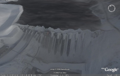
The Google Earth imagery of Revelstoke Dam in B.C. (below) looks like it was taken in the depths of winter. Since this is a massive concrete dam, I'm guessing the frost buckling in the image is an artifact of the surface model. Maybe Google need to add some more antifreeze to their TIN algorithm... or perhaps light a twig fire under their rendering engine?
Subscribe to:
Post Comments (Atom)


1 comment:
It's due to algorithms attempting to smooth the polygons for the high resolution terrain data Google acquired for the area. I think the tradeoff of a few areas that look wrong like this compared to the huge advantage of more accurate looking 3D terrain is worth the price. If it annoys you, just turn off the terrain layer, or look straight down while looking at the dam.
Post a Comment